MINNEAPOLIS, MN — A potentially dangerous and long-lasting weather setup is taking shape across a wide stretch of the central United States, and forecasters warn it could bring repeated rounds of severe storms to millions of residents from the Northern Plains all the way through the Great Lakes region later this week.
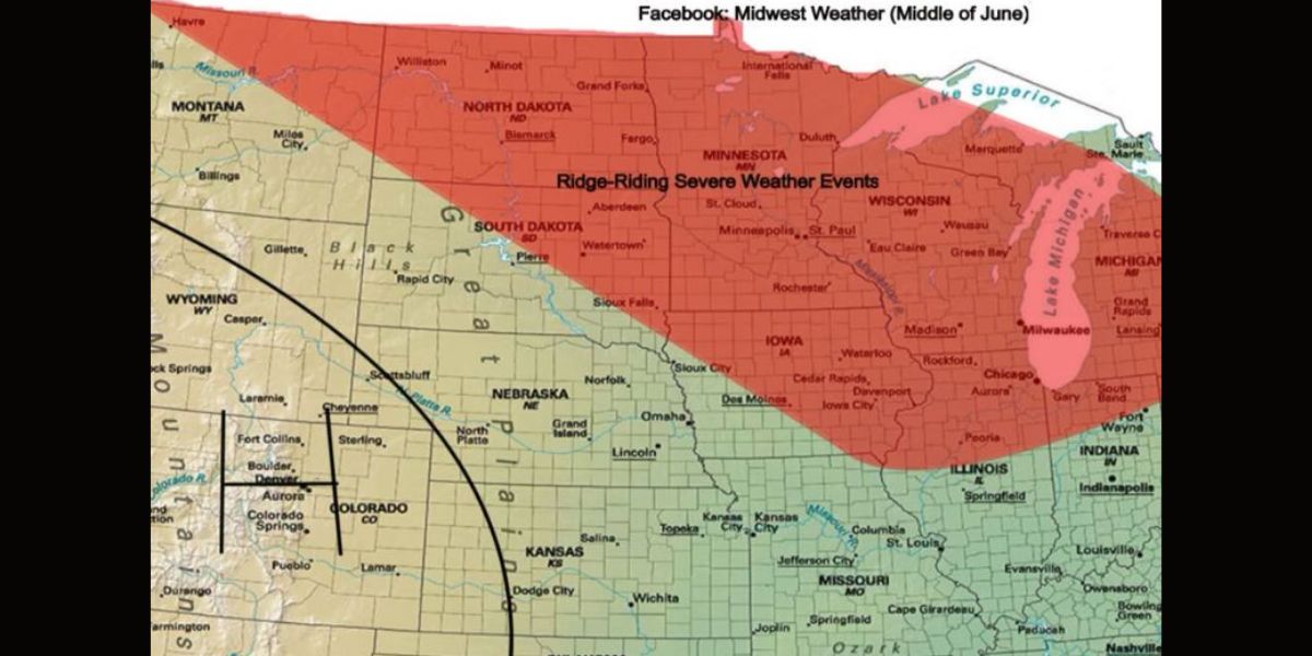
The pattern responsible is known as a “ring of fire” — a term meteorologists use when a powerful ridge of high pressure locks into place over one area, forcing storm systems to repeatedly wheel around its edges day after day. This week, that ridge is forecast to anchor itself over the central Mountain West, covering parts of Wyoming, Colorado, and western Nebraska.
What makes this particular setup more concerning than a typical summer pattern is a northwest flow component that forecasters say could allow large storm complexes to organize more effectively and last longer than usual. When that kind of atmospheric ingredient combines with ample moisture and instability at lower levels, the result can be mesoscale convective systems — large, powerful clusters of thunderstorms — that grow more intense and widespread as they move through the region.
The corridor facing the highest repeated severe weather risk stretches from Montana and North Dakota southeast through South Dakota, Minnesota, and Iowa, extending into Wisconsin and Michigan. Cities directly in the crosshairs include Bismarck, Fargo, Minneapolis, St. Paul, and Madison. Chicago and Milwaukee sit along the southeastern edge of the highlighted zone and are also included in the threat area.
Residents across all of these areas are urged to stay weather-aware through the end of the week, as the nearly daily severe weather threat means multiple rounds of potentially damaging storms are possible — not just a single event.
Have a plan in place, know your local alerts, and keep close watch on the forecast as this pattern fully develops. Conditions can change quickly when a ring of fire setup like this takes hold.